
HGS RESEARCH HIGHLIGHT – A Comparison of Sea-level Rise and Storm-Surge Overwash Effects on Groundwater Salinity of a Barrier Island
In this research highlight, researchers explored the impacts of storm surge overwash and sea-level rise on groundwater salinization at Assateague Island, a low-lying barrier island on the U.S. mid-Atlantic coast. The study used HydroGeoSphere (HGS) to simulate the coupled surface and subsurface flow processes that influence the island’s aquifer system. By modelling future sea-level rise and storm-surge events, the researchers aimed to better understand the long-term effects of climate change on groundwater resources, particularly the vulnerability of freshwater lenses to salinization.

HGS RESEARCH HIGHLIGHT – The effects of land subsidence and its mitigating measures on shallow groundwater salinization in the low-lying coastal plain of East Japan
The research investigates how land subsidence and mitigation measures, specifically pumping stations and ditch systems in Shirako Town, Japan's lower Nabaki River region, interact. Land subsidence, caused by natural and human factors, heightens flood risks in coastal areas, challenging infrastructure stability and environmental sustainability. While pumping stations and ditches aim to manage surface water levels and reduce floods, their impact on groundwater salinity near tidal rivers is unclear. Using a coupled surface-subsurface model, the study reveals potential risks like saline water intrusion into groundwater.

HGS RESEARCH HIGHLIGHT – The coastal aquifer recovery subject to storm surge: Effects of connected heterogeneity, physical barrier and surge frequency
This research analyzes the combined effects of connected heterogeneity, physical barriers, and surge frequency on coastal aquifer recovery. Using HydroGeoSphere (HGS), Aquanty’s sophisticated modeling platform known for its ability to simulate coupled surface water-groundwater interactions, the team investigated a series of modeling cases in heterogeneous and equivalent homogeneous aquifers.

HGS RESEARCH HIGHLIGHT – Saltwater Intrusion Into a Confined Island Aquifer Driven by Erosion, Changing Recharge, Sea-Level Rise, and Coastal Flooding
This research sheds light on the complex interactions between storm surges, reduced recharge, high erosion rates, and sea-level rise on the hydrological balance of Prince Edward Island. By leveraging the advanced capabilities of HGS, the researchers were able to test impact that climate change and future trends in coastal hydrology will have on the islands groundwater quality and the movement on the saltwater wedge underlying PEI.

HGS RESEARCH HIGHLIGHT - Mega-Tidal and Surface Flooding Controls on Coastal Groundwater and Saltwater Intrusion Within Agricultural Dikelands
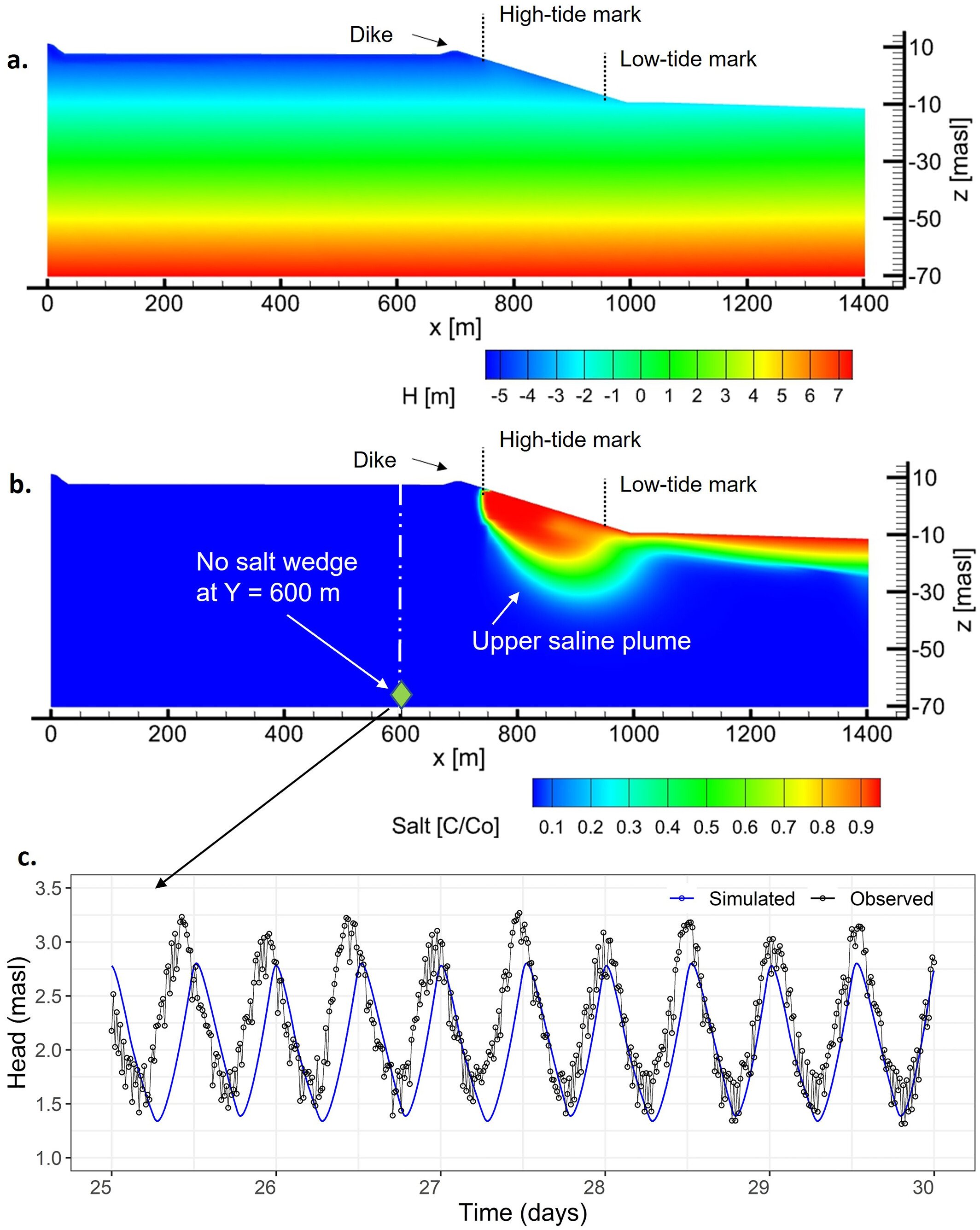
The study highlighted here makes full use of the density dependent flow modelling capabilities of HydroGeoSphere to investigate the impacts of climate change on groundwater-ocean interactions, and how sea-level rise, tides and storm-surges impact the long-term position of an upper saline plume in a coastal agricultural dikeland in Nova Scotia, Canada.

HydroGeoSphere Research Highlight - "Lateral and vertical saltwater intrusion into a coastal aquifer"
Climate change is projected to substantially increase the global mean sea level, which will adversely impact coastal communities worldwide.

HydroGeoSphere at the EGU23 General Assembly
HydroGeoSphere is usually well represented at the annual European Geoscience Union’s General Assembly, but 2023 might be a new record with 10 presentations which relied on the integrated hydrologic modelling capabilities of HGS.

HGS RESEARCH HIGHLIGHT – Coastal Topography and Hydrogeology Control Critical Groundwater Gradients and Potential Beach Surface Instability During Storm Surges
This work harnessed HydroGeoSphere to simulate storm surges and their geotechnical impact on coastal environments. The explicit coupling between the surface and subsurface domain revealed a non-trivial correlation between alongshore topography and the distribution of surge-induced critical gradients. It was found that, in contrast with traditional approaches, the lowest areas along a coastline are not necessarily the ones that are most vulnerable.

HGS RESEARCH HIGHLIGHT – Impacts of Coastal Shrimp Ponds on Saltwater Intrusion and Submarine Groundwater Discharge
This study investigates the potential impact that aquaculture can have on solute transport and saltwater intrusion in coastal settings. It is certainly an interesting read, and an interesting conceptual problem. Typically when we think of vertical saltwater intrusion it’s due to coastal inundation associated with temporary natural causes like storm surges. However, with shrimp pond aquaculture saline ponds are actually perched on top of agricultural soils, above a freshwater aquifer. In this study the authors have investigated several scenarios (varying pond water salinity, ponded water depth and farm/pond width) to see how it impacts a previously unrecognized/unstudied process contributing to groundwater salinization.

HGS RESEARCH HIGHLIGHT – Dynamic Steady State in Coastal Aquifers Is Driven by Multi‐Scale Cyclical Processes, Controlled by Aquifer Storativity.
A new paper explores the effects that periodic/cyclical processes over different time scales exert on salinity distribution throughout coastal aquifers. In other words, how is aquifer salinity impacted by sea-level changes caused by tidal effects (sub-daily), storm-surges (decadal) and glaciation (millennial scale).
