Webinar - Data Space Inversion: History-Matching, Uncertainty Analysis and Data Worth Assessment for Complex Models
CLICK HERE TO REGISTER
Note: all event times are in eastern (EST/EDT)
At Aquanty we take pride in offering the very highest quality of service by staying at the cutting-edge of hydrologic science and promoting the adoption of best-in-class scientific methods. In this webinar we’re excited to introduce the powerful Data Space Inversion (DSI) technique to the HydroGeoSphere user community and the wider Aquanty network.
Join us in welcoming Dr. John Doherty who will introduce the key concepts and theory behind DSI, and our good friend and long-time HGS user Dr. Hugo Delottier who will present an example application of the DSI technique applied to a complex HydroGeoSphere model.
Part 1: Data Space Inversion: History-Matching, Uncertainty Analysis and Data Worth Assessment for Complex Models
Abstract:
Data space inversion (DSI) has been around for a while but has been largely ignored, except by some in the petroleum industry. It is simple to understand and easy to implement. Nevertheless, it is extremely powerful.
Suppose that you have built a complex groundwater model with a lengthy run time. Presumably, you have done this because you are pursuing integrity of representation of processes that affect groundwater in your study area. The same ideal should impel you to seek integrity of representation of the properties that affect these processes. However these properties are heterogeneous, and often highly uncertain. They must therefore be represented stochastically. Stochastic representation of subsurface hydraulic and other properties supports quantification of the uncertainties of predictions of management interest - an essential pre-requisite for informed decision-making. However reduction of these uncertainties through history-matching faces severe practical difficulties when using a complex model.
In many circumstances, these difficulties can be overcome relatively easily using DSI. DSI allows you to capitalize on your modelling investment. In particular, from a machine-learning perspective, it allows you to reap the benefits of the exceptionally good receptacles that your model provides for information that is resident in measurements of historical system behaviour - for example, heads, fluxes and contaminant/tracer concentrations.
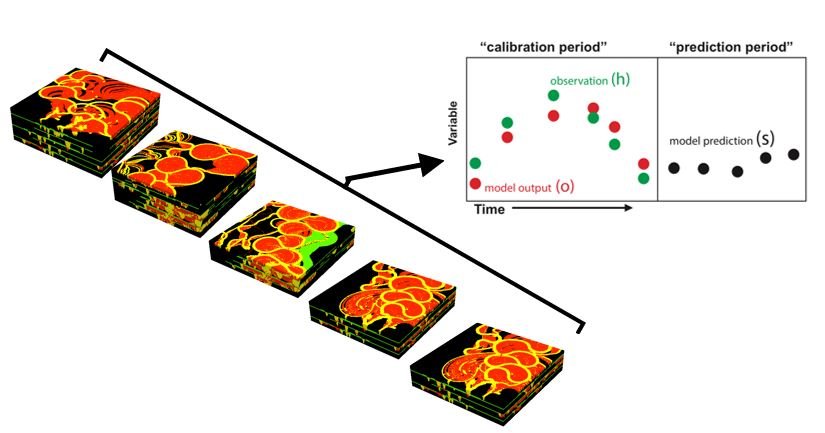
DSI uses your model to develop stochastic linkages between the measured past and the managed future. This statistical model can then be conditioned on real-world measurements of historical system behaviour to yield maximum-likelihood predictions of future system behaviour. Posterior (i.e. post-data-assimilation) uncertainties can then be ascribed to these predictions. All of this can be achieved at a fraction of the normal cost of history-matching – perhaps with as few as 300 model runs. This fast-running surrogate model can be turned to other useful tasks. For example, you can use it to assess the efficacy of different proposed data-acquisition strategies in reducing the uncertainties of predictions that you care about. Investments in data can therefore be optimized.
In short, at next to no numerical or financial cost, DSI allows you to add a large amount of value to your existing modelling work. DSI is supported by both the PEST and PEST++ suites.
Part 2: Data space inversion for efficient uncertainty quantification with integrated surface and subsurface hydrologic models
Abstract:
Hydrological models are generally built to provide decision-makers with useful predictions of future system behaviour. This allows them to better rationalise water use. The development of such models usually requires acceptable replication of historical system behaviour. It also requires quantification of the uncertainties of predictions of management interest. This is traditionally done by adjusting model parameters to fit historical observations of system states and may require a large number of model runs. Data Space Inversion (DSI) provides an alternative (and highly model-run-efficient) method for quantifying the uncertainties of model predictions by developing statistical relationships between simulated past and future system behaviour. DSI therefore eliminates the need for parameter adjustment. This is of great utility because it dramatically facilitates the quantification of prediction uncertainty for decision-support models with long run times and/or complex parameterisation schemes. DSI is used in conjunction with a complex hydrological model representing a synthetic but realistic alluvial phreatic aquifer to predict fast surface water travel times to water production wells as well as surface water infiltration. The performance of DSI for uncertainty quantification is validated against more traditional approaches that require adjustment of a large number of parameters. Efficient uncertainty quantification can be achieved with a significant reduction in computational time (about two orders of magnitude), demonstrating the benefits of using DSI in conjunction with complex hydrological models.
About the presenters:
Dr. John Doherty is the author of PEST and its associated utility software. John has worked in the water industry for over 40 years – in government, industry and academia. He was the 2019 Darcy lecturer. John presently devotes much of his time to software development and decision-support modelling research and education through the industry-funded GMDSI initiative.
Dr. Hugo Delottier is groundwater hydrologist focused on modeling flow and transport processes in heterogeneous porous and fractured media. Hugo obtained a PhD in hydrogeology from Université de Bordeaux in France under the supervision of Prof. Alexandre Pryet, with research focused on model predictive uncertainty quantification and groundwater recharge processes. Hugo has been involved in a major regional integrated surface and subsurface modeling project in the southern Québec region together with Prof. René Therrien (original creator of HydroGeoSphere). The main purpose was to investigate the potential effects of climate changes on regional groundwater resources. Today Hugo works with Prof. Philip Brunner as a Postdoctoral Researcher at the Centre for Hydrogeology and Geothermics (CHYN) at University of Neuchâtel, Switzerland, studying the explicit simulation of environmental tracers through the use of advanced numerical modeling methods to better inform complex alluvial geology.


