

HGS RESEARCH HIGHLIGHT – Fully integrated and physically-based approach for simulating water flows in a large-scale, heavily agricultural and low-instrumented watershed
This study is an excellent example of how a physics-based approach to simulating integrated hydrology with HydroGeoSphere allows researchers to overcome the limitations of data scarcity. Allowing water to flow naturally (or as ‘naturally’ as possible for a digital environment) also simplifies the calibration process, as a well conceptualized watershed scale model should be able to accurately represent the integrated hydrology of the watershed inherently.
HGS RESEARCH HIGHLIGHT – Estimation of groundwater contributions to Athabasca River, Alberta, Canada
This paper evaluates surface water-groundwater interactions within the Athabasca River Basin (ARB). The fully integrated nature of HydroGeoSphere was a key contributor to this study, as these simulations allowed for clear accounting of the interaction between groundwater and surface water, while also incorporating influential hydrologic mechanisms like snowmelt/accumulation and evapotranspiration over a very large area.

HGS RESEARCH HIGHLIGHT – Upscaling Hydrological Processes for Land Surface Models with a Two-Hydrologic-Variable Model: Application to the Little Washita Watershed
The authors have used a 3D HydroGeoSphere model of a heavily studied sub-catchment (the Little Washita Watershed, Oklahoma) as a reference point to test the validity of much simpler modelling approaches. Results of the 3D HydroGeoSphere model are compared against a simpler 2D hillslope model, also constructed using HydroGeoSphere.

HGS RESEARCH HIGHLIGHT – Subglacial Meltwater Recharge in the Dongkemadi River Basin, Yangtze River Source Region
The paper highlighted here is about the construction of a HydroGeoSphere model to simulate groundwater recharge due to the melting of water underneath a glacier under the influence of climate change, and represents the first attempts to account for the Dongkemadi Glacier in an integrated numerical model. The study site is a 40 km2, extensively glaciated catchment in the southwest portion of the Yangtze River Basin, on the Tibetan Plateau.
HGS RESEARCH HIGHLIGHT – Analysis of drought conditions and their impacts in a headwater stream in the Central European lower mountain ranges
A new study by researchers at the University Bayreuth investigates the impact that climate change may have on drought conditions in forested catchment with riparian wetland, specifically the Lehstenbach catchment in the Fichtel Mountains of South-Eastern Germany.
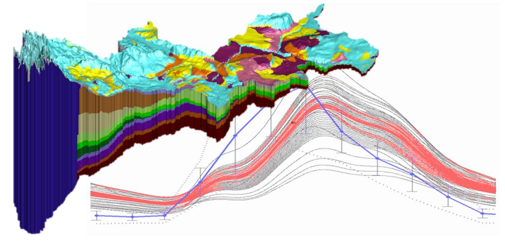
HGS RESEARCH HIGHLIGHT – Simulating fully-integrated hydrological dynamics in complex Alpine headwaters: potential and challenges
Alpine areas are inherently difficult to model, with large elevation gradients (steep, rugged terrain), complex geology and highly variable weather conditions, but nevertheless a satisfactory model calibration was achieved. The model incorporated fully integrated surface/groundwater flow, evapotranspiration processes, and dynamic snowmelt (using an energy balance-based representation of snow processes), all underpinned by a detailed 3D geological model.