Assigning Spatially Variable PM Properties using “Map property from raster for chosen elements”

If you have ever tried to assign spatially variable material properties in your HydroGeoSphere models using raster files, you will already know that there were several different command specific to individual properties. For example:
· Map porosity from raster
· Map isotropic K from raster
· Map anisotropic K from raster
· Map tortuosity from raster
And you may also know that there were no similar commands for some few properties (e.g. specific storage).
Well we decided that we could improve on this approach, so we’ve introduced a new command in the August 2022 version (revision 2432) that fills some of these gaps, and brings the functionality of all the commands above into one single, easy to use command. This new command is called Map property from raster for chosen elements, and it allows you to apply heterogeneous property values directly to chosen elements (including specific storage).
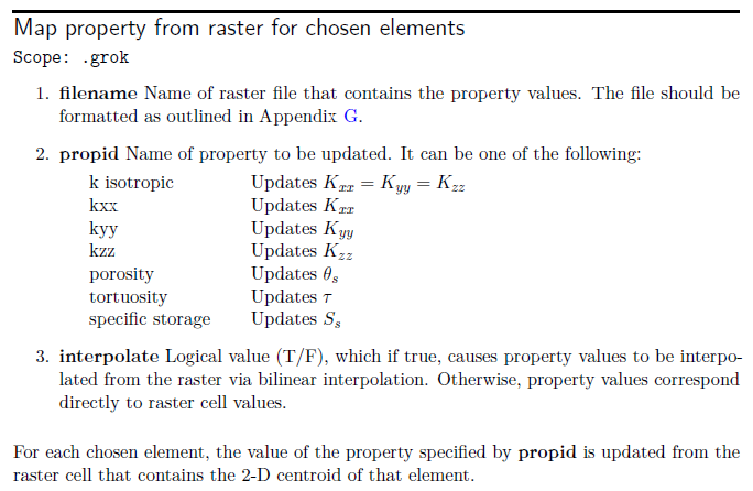
As an added bonus, you can also apply a bilinear interpolation to the property values which allows the elemental properties to transition smoothly from one property ‘zone’ (as defined by the raster file) to another.
Note: the new command must be applied directly to selected elements, and NOT to a selected property zone. Furthermore, the scope of this command is restricted directly to the .grok file – you can’t use this technique in the context of the material property file (i.e. .mprops).
We have created a new version of the R5 ‘Intro to HydroGeoSphere’ tutorial (original tutorial here) to demonstrate the use of this new command.
Click here to download the ‘R5_property_rasters’ example problem.
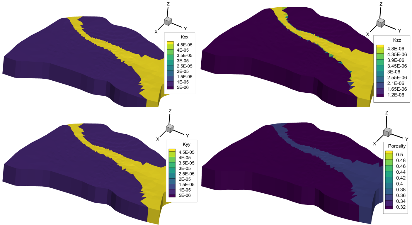
In this simplified version of the R5 model we have applied spatially varying Kxx, Kyy, Kzz, porosity and specific storage to the entire model domain (with the exception of a small clay lens). We’ve also demonstrated the linear interpolation capability for the Kzz property field. Finally, we’ve written the conductivity and porosity fields to Tecplot for visualization (see this post for more info about ‘to tecplot’ commands). Lines 89-148 of the R5.grok file assign these porous media properties:
-
!!-------------------------- Porous media properties
! We now have a model mesh with 8 layers. Layer #5 (i.e. Unit #3 above) contains a small clay lens that will have homogeneous material properties.
! These clay properties are defined in the associated material properties file (R5.mprops).
! The rest of the PM domain will have spatially variable saturated flow properties applied using the command "Map property from raster for chosen elements".
! Unsaturated flow properties are homogeneous and use default values.
use domain type
porous media
clear chosen elements
choose elements all
Map property from raster for chosen elements
./data/KxKy.asc
Kxx
False
Map property from raster for chosen elements
./data/KxKy.asc
Kyy
False
Map property from raster for chosen elements
./data/Kz.asc
Kzz
True
Map property from raster for chosen elements
./data/Porosity.asc
porosity
False
Map property from raster for chosen elements
./data/Ss.asc
specific storage
False
! Clay lense properties
properties file
R5.mprops
clear chosen elements
choose elements am
./data/Clay_lens.echos
5, 6
new zone
2
clear chosen zones
choose zone number
2
read properties
Clay
K to tecplot
mesh_K_Tecplot.dat
porosity to tecplot
mesh_Porosity_Tecplot.dat
You can see the resulting distribution of PM domain properties in the image below (note the linear interpolation of Kzz).
We hope this new command will simplify the process of applying heterogeneous properties to your models. Let us know if you have any suggestions on how we could improve this command!